Sunday, October 23, 2005


Sun setting in Sedona! Posted by Picasa

Devils Kitchen "sinkhole" on Sedona hike. Crew "rescure training" in the sinkhole! Posted by Picasa

Montezuma's Castle near Camp Verde - built in 12th Century. Posted by Picasa

Camp Verde and Sedona Area

Oct 18 - 23.... Camp Verde, AZ. We are located south of Flagstaff and about 90 miles north of Phoenix. The weather has been wonderful - warm days and cool nights. We spent one day driving the countryside and taking in, Jerome, Tuizigoot Indian Ruins and Montezuma's Castle. Jerome is a historic mining/ghost town, Tuizigoot is the remnant of a Southern Singua village built between A.D. 1125 and 1400 and Montezuma's Castle is a five-story, 2- room dwelling built in the 12th century. It stands in a cliff recess about 100 ft above the valley. Friday we drove the short distance to Sedona - another beautiful area of red rocks. In case you haven't figured it out we are enthralled with red rocks/mountains! While in Sedona we decided to take another hike. The hike to Soldiers Pass was to have been a 2.3 miles hike one-way. Along the way another hiker asked us if we were going to go the "loop" - so once we got to what we thought was the top we continued on another trail to complete the "loop". After 1.5 hrs we decided we better turn back as we seemed to be getting further and further away from our car. After going a short distance back we ran in to another couple from Michigan and we all decided we were about half-way so we would continue the "loop". Well, after another 1.5 hrs of hiking we found our cars! After reviewing the map we determined we hiked somewhere between 6 and 7 miles - we were on the trail for just over 3 hours. The view was incredible but our legs & other body parts were screamin! After that we found the local "brewery" and relaxed a little. And NO we didn't even walk into a store! Saturday we decided to rest - we washed and waxed the Motorhome.....another lengthy project~ Our next door neighbors just happen to be from Chicago (as in the White Soxs). We watched the first game of the World Series with them in their motorhome (so it was only fitting that they won the first game)! We (Houston Astros) intend to win the game tonight! We leave for Yuma, AZ on Wednesday where we will spend 2 weeks!

Monday, October 17, 2005


Sunset at Yavapoi Point- Grand Canyon South Rim Posted by Picasa

Mather Point - Grand Canyon South Rim Posted by Picasa

Us resting at Ooh Aah Point after our hike down the South Kaibab Trail


Us resting on our hike down 600ft - Kaibab Trail Posted by Picasa

Mike at Hermits Rest Posted by Picasa

Grand Canyon National Park

Oct 13 - 17....Grand Canyon National Park -- what can we say, it was GRAND! The Grand Canyon is truly a site all of it's own. We walked about 2 miles on the South Rim walking path the first day we got there. We took in the sunset and even the sunrise overlooking the canyon. We were out there at 610am (that's early for us now). Both the sunset and sunrise was a beautiful site. The pictures turned out the best at sunset. It was kinda hazy (pollution from CA & AZ according to the signs). One day we decided to try a hike down into the Canyon. We left from Yaki Point and hiked down & "back up" 600ft - 3/4 miles each way. It wasn't very far but it was pretty 'straight' down. Once you get over that weird feeling looking down it wasn't bad. They say to allow twice as long coming back up as going down - we made it in 35 minutes down and 40 minutes up (were in better shape than we thought! Next trip to the canyon we would like to make the hike down to the bottom to the Colorado River (7-10 miles depending on the trail) & overnight at the Phantom Ranch and then return up the next day. We will definitely need to be in better shape & be better equipped - we're getting into this hiking thing! We met a few guys that hiked down from the North Rim and were on their way back up to the South Rim - 14 miles down and 7 up (obviously that didn't happen in one day). There are caution signs everywhere advising not to go down and up in the same day. We pretty much covered the South Rim of the Canyon - from Desert View to Hermits Rest! Speaking of getting in shape, we didn't start off to good today as we stopped at 'Twisters Soda Fountain' on Historic Route 66 in Williams where we had a milkshake! Today we are headed to Camp Verde, AZ.

Wednesday, October 12, 2005


The view of Monument Valley as seen in many movies and commercials Posted by Picasa

The "West Mitten Butte". Hike to and completly around this. East Mitten Butte in background. We were on the valley floor the monument is about 2000ft up. Posted by Picasa

Arch that was a 1/2 mile up from the Gouldings RV Park. The view from the other side was amazing! Posted by Picasa

House built in the rock "Hole n' the Rock Posted by Picasa

Monument Valley

Oct 11 - 12....Just a few miles south of Moab we stopped at a place called "Hole n' the Rock" where a Danish couple carved their 5000 sq ft house inside the rock in the 1940's. It was pretty amazing! See the above picture for a glimpse at what it looked like. We continued on to our destination of Gouldings in Monument Valley. The RV park is nestled in red rock mountains. There was a great hike just out our door that took us to another arch that mother nature carved out of these phenomenal mountains. The view from this area was another awesome site. Today we toured the museum at the Gouldings Lodge that showed the Navajo way of life, many props from movies filmed in this area, and the life of the Gouldings. From there we drove the 4 miles to the Navajo Tribal Park were we drove a very ruff road to view this beautiful valley. We hiked to and around the circumference of the "West Mitten Butte". According to the brochure the hike was a 3.3 mile loop. According to my pedometer it was much further! The trail in many parts was like walking on a very sandy beach - the difference was this was red sand and it was up and down for a large part of the hike. Try walking up hill in deep sand in hiking boots - our legs are feeling it now! The trail was not really developed - many times we were walking through washes looking for the small stack of rocks that were put here and there to show where the trail is. All and all it was a great hike and of course the view was spectacular! Tomorrow we are off to the Grand Canyon's South Rim.

Monday, October 10, 2005


This is what you see for miles at Arches National Park! Posted by Picasa

"Landscape Arch" the opening is larger than a football field! A large section fell off in 1991 so this is as close as you can get now! Posted by Picasa

"Delicate Arch" - the symbol of Utah (it's on the UT license plate) Next time we will make the hike right to it!  Posted by Picasa

The "Balanced Rock" - Arches Natl Park Posted by Picasa

Road between Gunnison & Montrose on Oct 9th Posted by Picasa

Arches National Park

Oct 9 - 10....We left Blue Mesa on Monday and ran into snow between Gunnison and Montrose. The snow & frost was on the side of the road and the mountains but only slush on the road. It only lasted for a few miles and then we had rain off and on. Today, on the day Columbus discovered America, we discovered the most unique National Park that we have seen so far in our travels. Arches National Park is just 5 mile north of Moab, Utah. This is the most awesome park that we have ever seen. There is red rock and formations everywhere you look. We drove through the park and hiked to Landscape Arch, hiked to viewed Delicate Arch (which is on the UT license plate), and saw many named arches and formations. It was truly awesome and we will definitely come back again to explore more of the beautiful sites. After the park we drove on river road 128 and went to the Castle Rock Winery and went through a museum showing all the movies, commercials and photos made in this area. There were many! This is where Thelma and Louise drove their car off the cliff. If you have seen Stagecoach with John Wayne and the City Slickers movies, not to mention about every Marlboro ad - this is where they were filmed. The town of Moab has lots to offer the adventurous from river rafting the sky diving Tomorrow we go south to see more of red rocks and sites unknown of Utah!

Saturday, October 08, 2005


The Dillon Pinnacles - as close as we got on the trail Posted by Picasa

Dillon Pinnacle midway into the hike Posted by Picasa

Dixie on the 1st hike -there is a drop off behind that you don't see Posted by Picasa

View from the 1st hike - the RV park below Posted by Picasa

Gunnison, CO

Oct 2 - 8....On Monday we left Breckenridge and continued on to Gunnison, CO. We are staying at the Blue Mesa Ranch, which is located 12 miles west of Gunnison. The RV park overlooks the Blue Mesa Reservoir and mountains on all sides. The view from our door is once again spectacular. The weather has been good - the highs in the 50's to 70's and a low of 27. We have been on 2 hikes and spent some time at the driving range practicing our golf shot (and we need lots of practice). The first hike was from the RV park going up the mountain - we started out on a horse trail, then onto an ATV trail and then we found ourselves on a "deer" trail (we even saw some deer in the distance). We thought we could find our way back to camp but soon found that it went down much steeper than it appeared so we picked our way back to the trail and returned the same way we came. Four miles & 2 hours later we got back to the motorhome. It was worth it as the view was wonderful. We took some pictures from the top overlooking the park but you don't get the jest of how far up we were. The 2nd hike we did today - it was another 4 mile hike. We drove down the road a few miles and took the hike UP the "Dillon Pinnacles" trail. The pinnacles were formed by volcanic activity 35 million years ago. It's quite a site. The view in the other direction is the Blue Mesa Reservoir and Dam (this is the largest body of water in Colorado). They are expecting snow on Sunday night into Monday so we decided we will head out tomorrow instead of Monday. Next stop is Moab, UT for 2 nights and then Monument Valley, UT for 2 nights. Sounds like more hiking to come!

Saturday, October 01, 2005


View of the Aspen colors in Breckenridge Posted by Picasa

The view from our front door - after the snow. Posted by Picasa

Hiking the Colorado Trail, overlooking the park -before the snow. Posted by Picasa

Our Colorado Trek

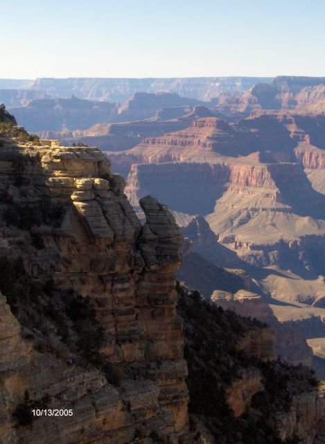
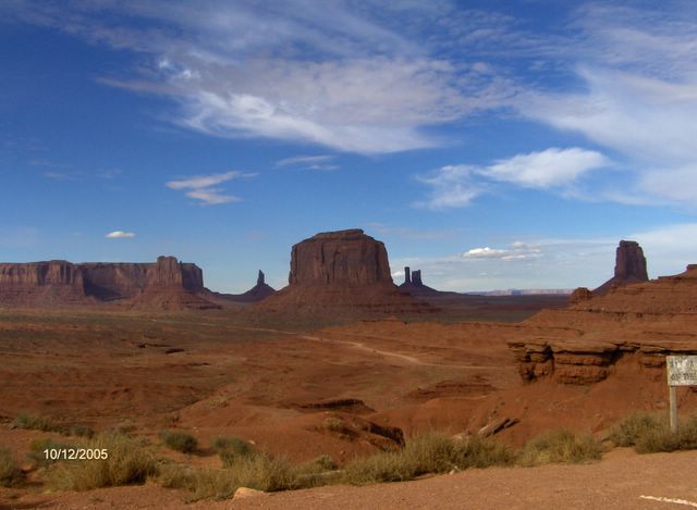
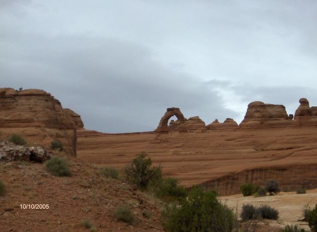
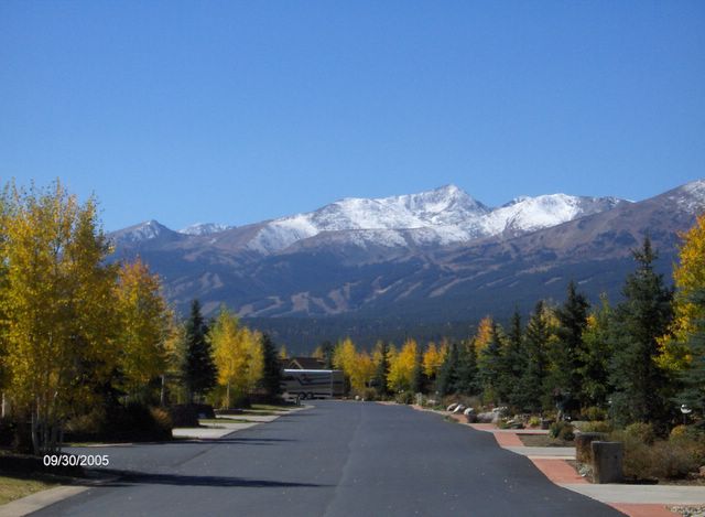
Sept 24-Oct 1...We started our week out attending the Colorado Rockies baseball game. It was their last home game of the season, playing the San Francisco Giants. The game was good but it didn't turn out so well for the Rockies. On Monday we made our way to Breckenridge, where we are staying at a beautiful RV park called Tiger Run. It's located just 3 miles north of Breckenridge and we would highly recommend the park. There are several sites with Chalets (park model homes) that people own as well as RV sites that you can buy or rent. The park has 2 small rivers running throught it and is a top of the line park. We have spent our week hiking, biking, walking, and touring. We have visited the towns of Breckenridge, Frisco, Silverthorne, Dillon and Vail - all very unique. It is a beautiful time of the year here as the Aspen tree leaves are turning. The gold colors mixed in with the green are like nothing we have seen before. It has been in the 60's in the day and low 30's at night. It rained on Tuesday night and on Wednesday morning we woke up to snow capped mountains right outside our door. We will be leaving for Gunnison on Monday for a week and then head south...We don't want to push our luck - we want out of this area before the snow flies and lands on our steps! It suppose to be 28 degrees for the next 2 nights - anything below freezing is too cold for us!